Difference between revisions of "GPS Coordinates"
(Created page with " == GPS Coordinates == When entering coordinates into any field labeled GPS Location, Mission Manager understands many different formats. These formats include Decimal Lat...") |
|||
| (4 intermediate revisions by the same user not shown) | |||
| Line 1: | Line 1: | ||
| − | |||
| − | |||
| − | |||
| − | |||
When entering coordinates into any field labeled GPS Location, Mission Manager understands many different formats. These formats include Decimal Latitude / Longitude, Universal Transverse Mercator (UTM), US National Grid (USNG), Degrees/Minutes/Seconds, or Degrees Decimal Minutes or NSARC (National Search And Rescue Committee) Latitude / Longitude format. Mission Manager will display GPS coordinates on Mission Screens in the format selected in the [[Configuration]] setting <u>'''Mapping Coordinate Display'''</u>. | When entering coordinates into any field labeled GPS Location, Mission Manager understands many different formats. These formats include Decimal Latitude / Longitude, Universal Transverse Mercator (UTM), US National Grid (USNG), Degrees/Minutes/Seconds, or Degrees Decimal Minutes or NSARC (National Search And Rescue Committee) Latitude / Longitude format. Mission Manager will display GPS coordinates on Mission Screens in the format selected in the [[Configuration]] setting <u>'''Mapping Coordinate Display'''</u>. | ||
| − | Note that when typing a Degrees/Minutes/Seconds or Degrees Decimal Minutes coordinate - °, d or D are equivalent characters. | + | Note that when typing a Degrees/Minutes/Seconds or Degrees Decimal Minutes coordinate - [°, d or D] are equivalent characters. |
The following are some sample coordinates that can be entered into any field that refer to a GPS location, as well as the Find box on the maps page: | The following are some sample coordinates that can be entered into any field that refer to a GPS location, as well as the Find box on the maps page: | ||
| Line 63: | Line 59: | ||
*N28 34.190 W080 59.783 | *N28 34.190 W080 59.783 | ||
| + | |||
| + | '''GPS Location Calculator'''- a tool is available on many different Mission Manager pages by clicking on this icon [[File:Help GPSCalc3.PNG]]. This tool provides the ability to convert between many different coordinate formats and then map the location (see below image). After filling in one of the coordinate lines in the correct format, click on the <u>Calculate</u> button to populate the converted formats. The location can then be mapped by clicking on the <u>Map</u> button. | ||
| + | |||
| + | [[File:Help GPSCalc2.PNG]] [[File:Help GPSCalc4.PNG]] | ||
Latest revision as of 01:37, 15 September 2014
When entering coordinates into any field labeled GPS Location, Mission Manager understands many different formats. These formats include Decimal Latitude / Longitude, Universal Transverse Mercator (UTM), US National Grid (USNG), Degrees/Minutes/Seconds, or Degrees Decimal Minutes or NSARC (National Search And Rescue Committee) Latitude / Longitude format. Mission Manager will display GPS coordinates on Mission Screens in the format selected in the Configuration setting Mapping Coordinate Display.
Note that when typing a Degrees/Minutes/Seconds or Degrees Decimal Minutes coordinate - [°, d or D] are equivalent characters.
The following are some sample coordinates that can be entered into any field that refer to a GPS location, as well as the Find box on the maps page:
- 32.830738, -116.866808
- 32.830738N, 116.866808W
- 32.830738 N, -116.866808 W
- 32.830738 -116.866808
- 32.830738N 116.866808W
- 32.830738 N -116.866808 W
- UTM 485184 3618184 (Note: when entering UTM coordinates, and the zone is not specified, the map location should be near the area in question. The current UTM zone of the map displayed is used to find the typed in UTM location.)
- 498635,3651766
- 498635,3651766 (Zone 11)
- 498635,3651766 Z11
- USNG 11S MS 87491 42805
- NSARC 33-54.933N,108-29.532W
- DMS 27°42'53.200",-81°59'40.876"
- DMM 28°18.821,-82°2.812
- 33-54.933N,108-29.532W
- N33-54.933,W108-29.532
- 11S MS 98635 51766
- 33°0'15.5700",-117°0'52.6140"
- 33d0'15.5700",-117d0'52.6140"
- 33d 0' 15.5700",-117° 0' 52.6140"
- 33°0.2595,-117°0.8769
- 33D0.2595,-117D0.8769
- 33°0.2595 -117°0.8769
- 33D0.2595 -117D0.8769
- 33D0.2595 N,117D0.8769 W
- N28 34.190, W080 59.783
- N28 34.190 W080 59.783
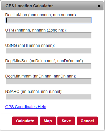
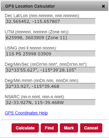
GPS Location Calculator- a tool is available on many different Mission Manager pages by clicking on this icon . This tool provides the ability to convert between many different coordinate formats and then map the location (see below image). After filling in one of the coordinate lines in the correct format, click on the Calculate button to populate the converted formats. The location can then be mapped by clicking on the Map button.

